
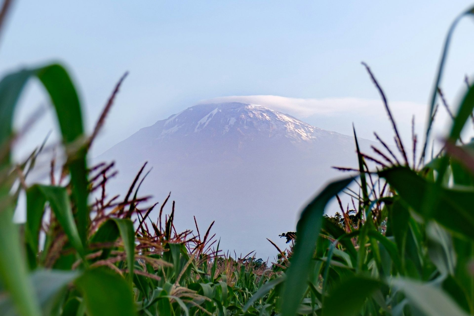
from the fertile grounds around Moshi the destination can already bee seen clearly
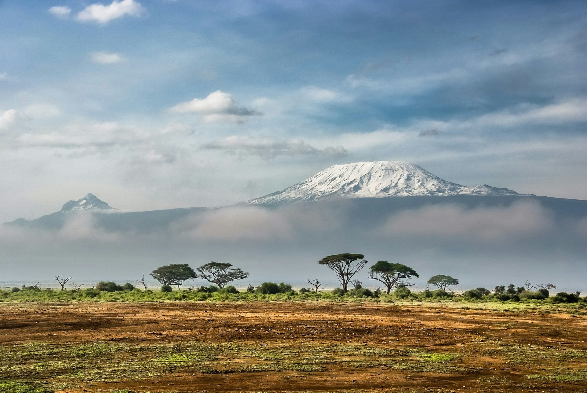
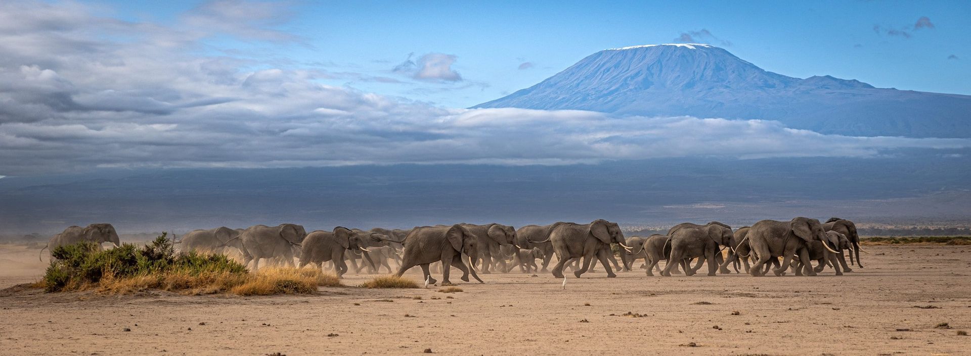
from the savannah
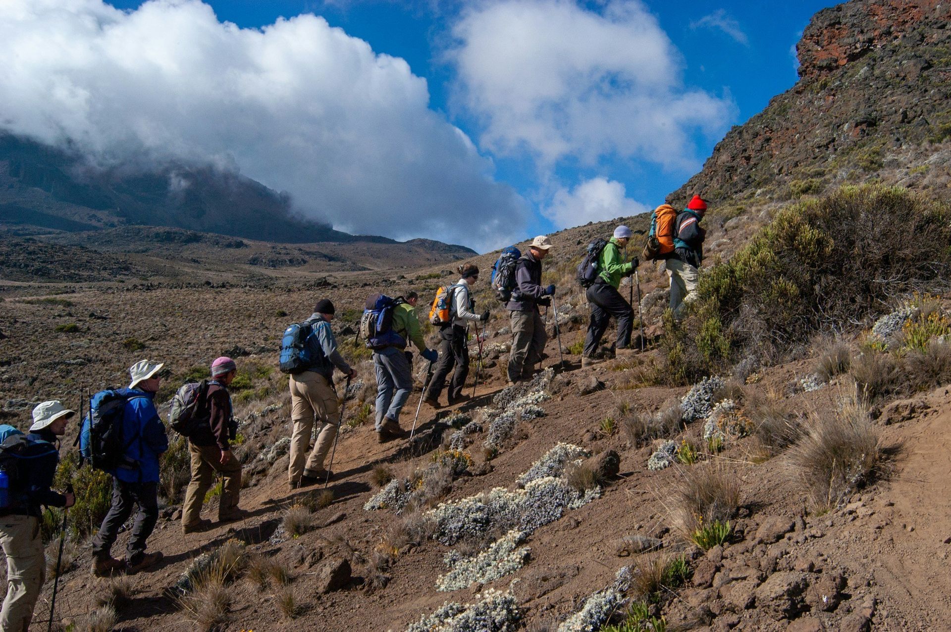
single file, the early stages
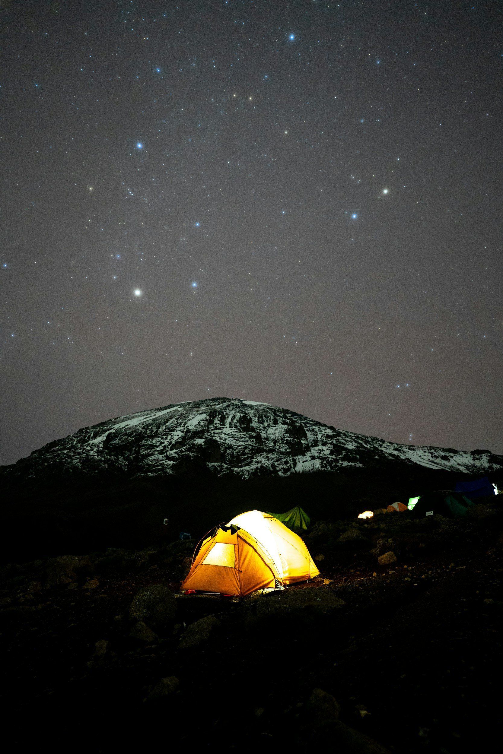
get used to staying in a tent - and starry nights
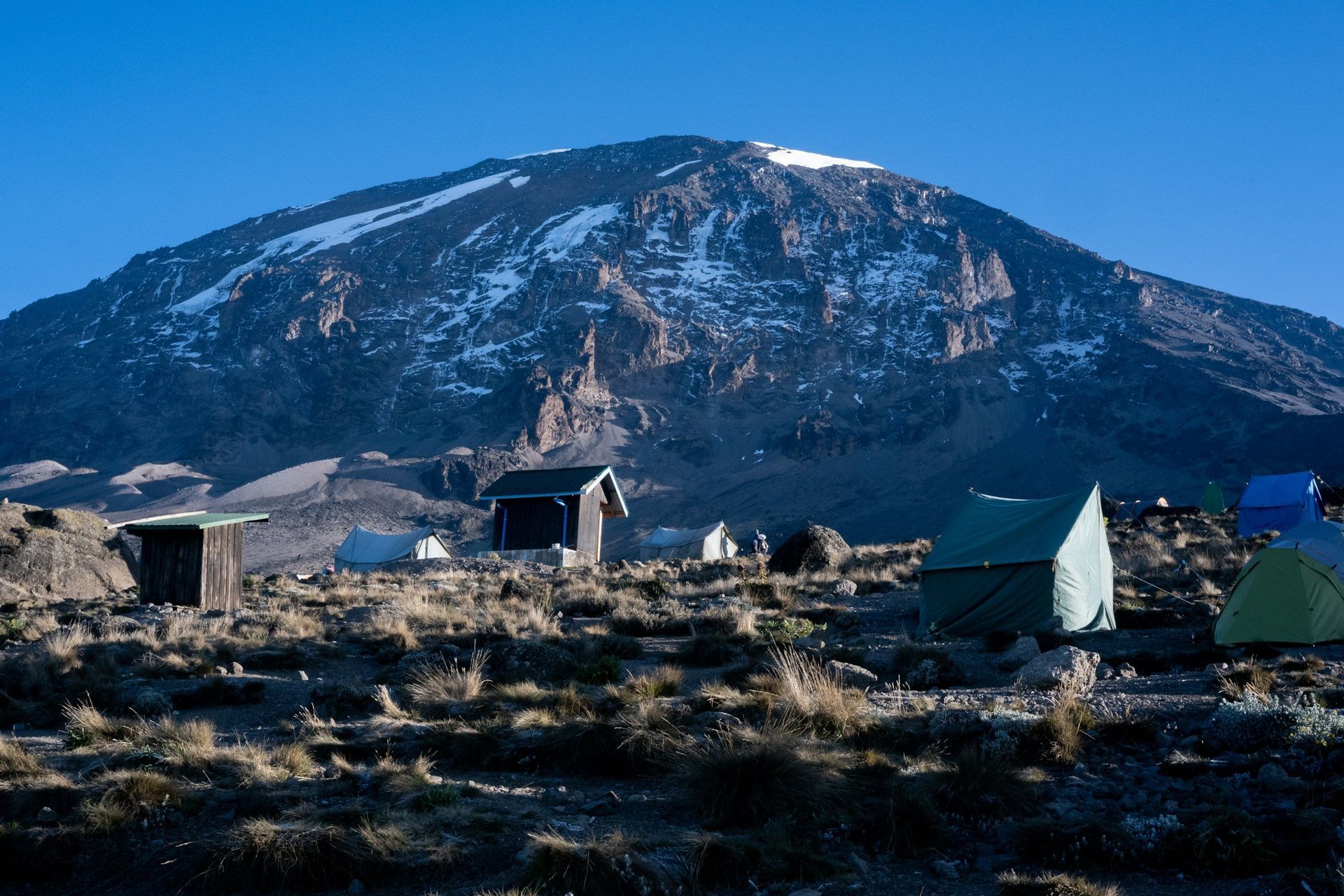
last camp before the summit attempts
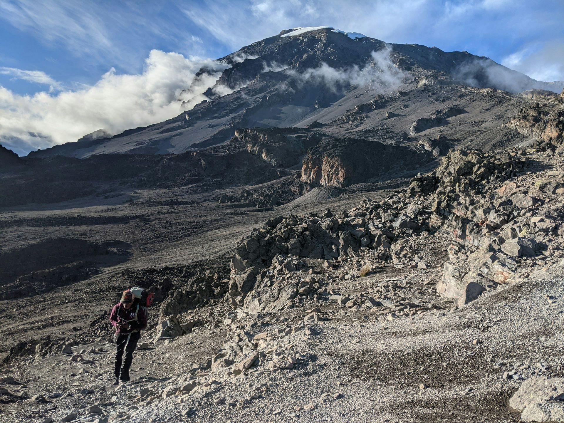
the saddle area
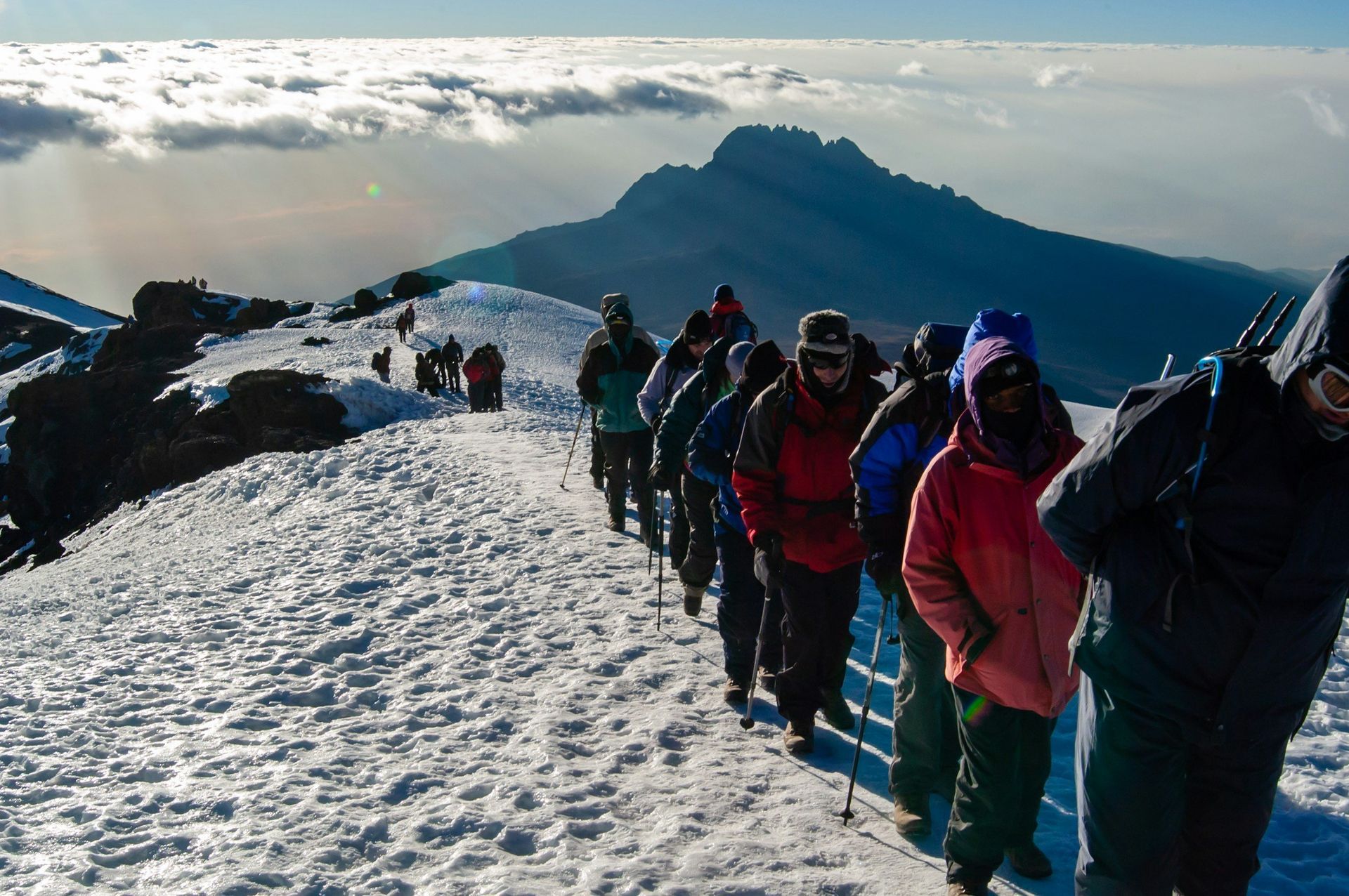
higher and higher means colder and colder
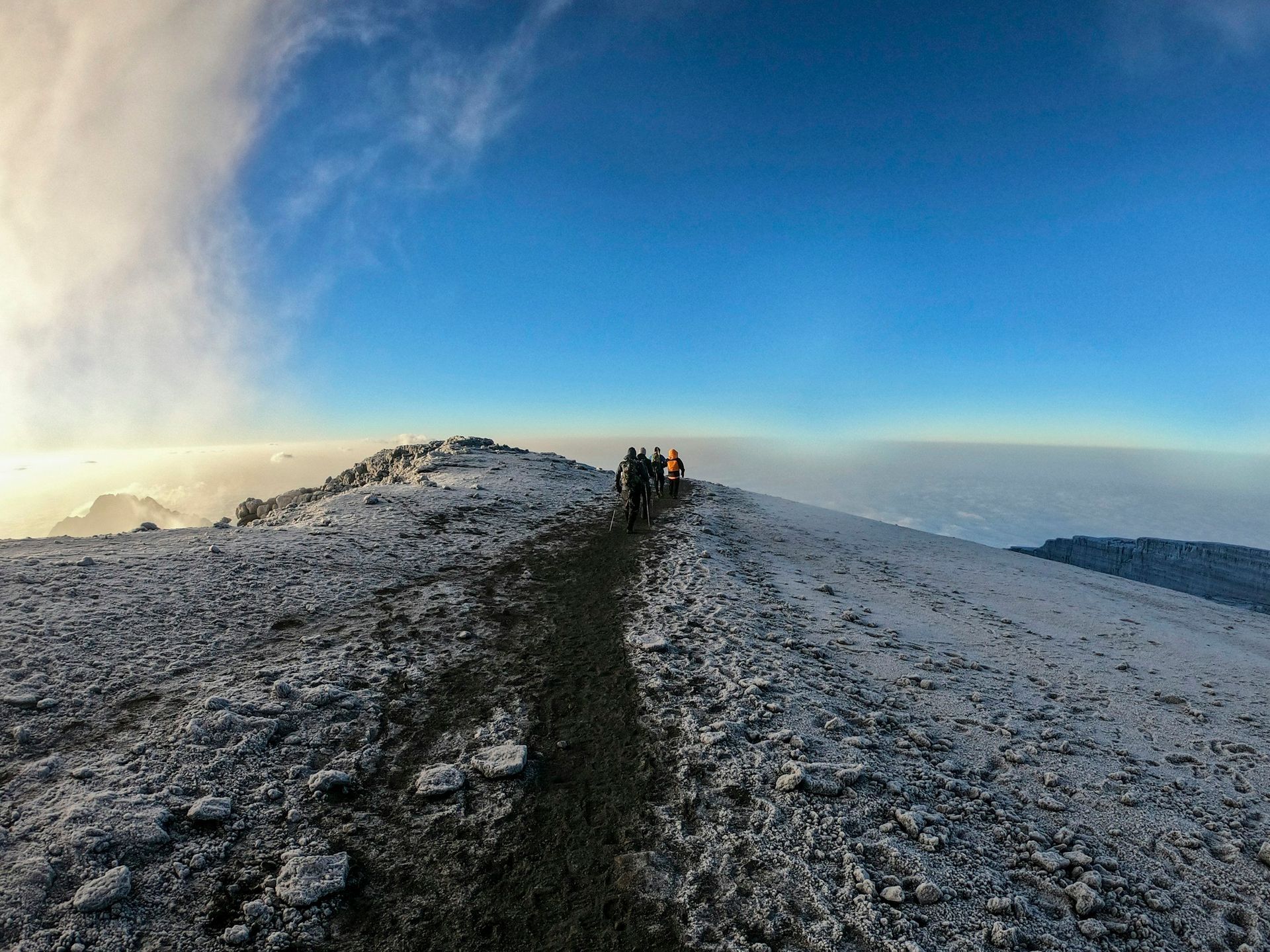
getting close to the summit
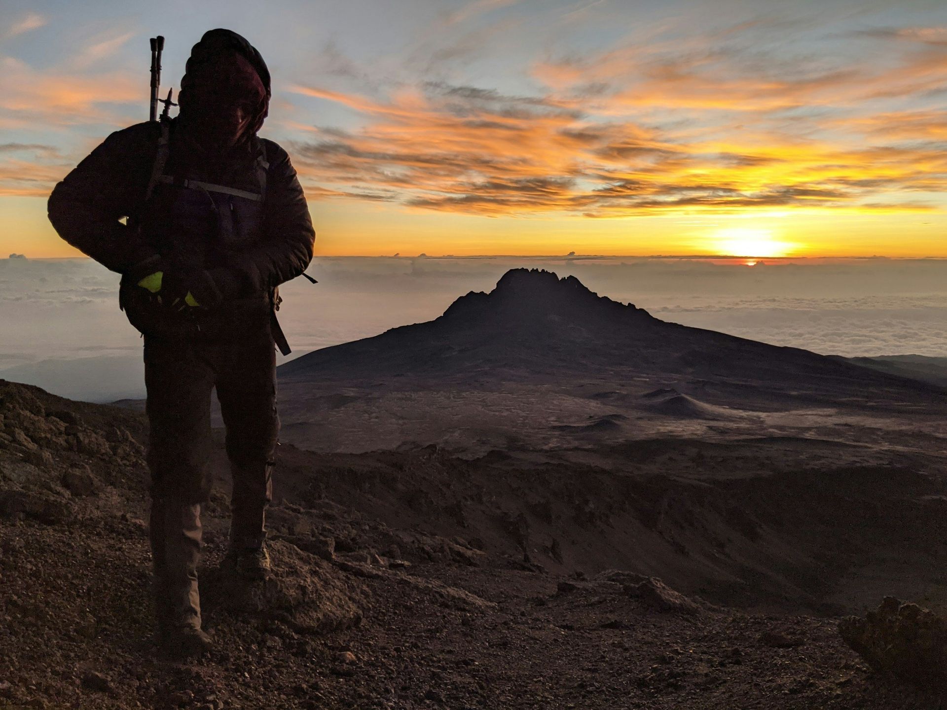
sunrise
we say goodbye to the mountain
EUROPE — 7 top EV destinations 1. Norway – best overall EV destination Norway has incentivized electrical vehicles for many years, including perks when it comes to parking among others. Roads are never quite boring in this country and there’s long stretches in tunnels underneath vast rock formations including futuristic roundabouts! Why it’s great: Highest EV adoption rate in the world Reliable fast-charging along major tourist routes Stunning fjords, mountains, national parks Best for: ✔ Scenic road trips ✔ Nature-heavy holidays ✔ Long-distance EV travel ✔ Families & couples 2. Netherlands – best for easy, stress-free EV travel It’s not hard to find charging stations in this country - as well as to rent electric vehicles from one of the many renting and sharing platforms. No worries about range anxiety in this compact, flat country too. Just make sure to avoid rush our traffic around the major cities if you don’t want to be stuck in slow moving traffic for a good hour or so. Why it’s great: Densest public charging network in Europe Compact geography Flat, easy roads with short distances between towns EVs widely available at rental companies and sharing platforms Best for: ✔ City hopping ✔ Weekend breaks ✔ Beginner EV travellers 3. Germany – best for efficiency + excellent highways Why it’s great: Major charging corridors on Autobahns Lots of EV choices from rental agencies Well-mapped charger networks Mix of cities, medieval towns & countryside Best for: ✔ Long-distance touring ✔ Multi-country European road trips ✔ Culture + nature combo itineraries 4. France – best for diverse landscapes + big tourism regions Why it’s great: Extensive public chargers, especially on autoroutes Great EV suitability in regions like Provence, Loire Valley & Normandy Hotels increasingly offer overnight charging Best for: ✔ Wine routes ✔ Beach holidays ✔ Romantic trips 5. Sweden – best for northern nature road trips Why it’s great: Strong EV culture Good coverage from cities up through central Sweden Lakes, forests, wildlife-rich areas ideal for slow travel Best for: ✔ Summer nature road trips ✔ Family holidays ✔ Slow-travel vacations 6. Austria – best for alpine driving Why it’s great: Plenty of chargers around cities and tourist villages Hotels often provide easy charging Perfect mix of scenic mountain routes + cultural cities Best for: ✔ Alpine scenery ✔ Winter + summer trips ✔ City + mountain mix holidays 7. Belgium – best for compact, easy EV routes Why it’s great: Dense EV charging network Short distances between major towns Very EV-friendly for tourists Best for: ✔ Cultural city breaks ✔ Couples’ weekend trips ASIA — top 5 EV destinations 1. China – best overall EV destination in asia Why it’s great: World’s largest EV charging network Many high-speed chargers on highways EV rentals widely available Great for city-to-city trips (Shanghai → Hangzhou, Shenzhen → Guangzhou) Best for: ✔ Urban travel ✔ Scenic intercity routes ✔ High-tech travel experiences 2. South Korea – best for dense, reliable charging Why it’s great: One of the best charger-to-EV ratios globally Fast-charger availability very strong in developed regions Road quality excellent Best for: ✔ Seoul + Busan + Jeju holiday circuits ✔ Short-to-medium EV road trips ✔ Tech-loving travellers 3. Japan – best for organized, predictable routes Why it’s great: Improving EV infrastructure Predictable charging around major corridors Popular for short scenic routes: Tokyo → Hakone, Kyoto → Nara, Osaka → Wakayama Best for: ✔ City + nature combos ✔ Short scenic drives ✔ First-time EV renters in Asia 4. Singapore + Malaysia – best for smooth, modern SE Asia EV travel Why it’s great: Singapore offers very dense charging & excellent EV rentals Malaysia rapidly expanding fast chargers on main expressways Easy, safe cross-border EV travel Best for: ✔ Short-to-medium road trips ✔ Family holidays ✔ Beach + city mix trips 5. Thailand – best for city-based holidays with local EV travel Why it’s great: EV infrastructure growing rapidly in Bangkok, Chiang Mai, Phuket Short-distance sightseeing is very EV-friendly Ideal if you stay in popular regions Best for: ✔ Island + city combos (with planning) ✔ Eco-friendly travellers ✔ Couples looking for easy urban EV use

Colivings have rapidly transitioned from a niche housing trend for digital nomads to a mainstream accommodation choice across European capitals (and on the countryside too). From the tech hubs of Berlin and Lisbon to the historic centers of Prague and Budapest , it offers a distinct alternative to traditional renting.
Europe is a paradise for hikers. From alpine giants to sun-soaked coastal paths, the continent is packed with world-class trails that blend natural beauty, culture, and adventure. Whether you’re planning your next big trek or searching for a weekend escape, this guide covers the top 10 outdoor hikes in Europe , why each one belongs on your bucket list, and exactly how to reach them .

The Czech Republic, often called Czechia, is a landlocked country in Central Europe renowned for its stunning medieval architecture, fairy-tale castles, rolling countryside, and vibrant cultural scene. It's also the country where lager beer originated! Bordered by Germany, Austria, Slovakia, and Poland, it offers a mix of historic cities like Prague, charming towns, natural parks, and a rich brewing heritage. With a population of about 10.5 million, it's a safe, affordable destination that's easy to navigate. Whether you're into history, outdoor adventures, or wine tasting, Czechia has something for everyone. This guide covers everything from arrival to exploration, drawing on up-to-date information for 2026 travel. Best Time to Visit Czechia experiences four distinct seasons. The peak tourist season is May to September, with warm weather averaging 25°C (77°F) in summer—ideal for sightseeing and festivals, though Prague can get crowded in July and August. Shoulder seasons (March-May and September-October) offer milder temperatures around 14°C (59°F), fewer crowds, and opportunities for hiking or autumn foliage. Winter (December-February) brings snow, Christmas markets, and skiing, but expect cold snaps below freezing. For wellness retreats or wine tours, spring or fall is perfect. Avoid major holidays like Easter or Christmas if you prefer quieter visits. How to Get There Czechia is well-connected to the rest of Europe and beyond, with Prague serving as the main gateway. - By Air: The primary international airport is Václav Havel Airport Prague (PRG), about 10 miles from the city center. Direct flights arrive from major European hubs (e.g., London, Paris, Berlin) via airlines like Ryanair, EasyJet, or Czech Airlines. From the US, expect connections through cities like Frankfurt or Amsterdam; non-stop options from New York or Chicago take about 8-10 hours. Budget around 5,000-15,000 CZK (200-600 USD) for round-trip economy from Europe, or 20,000-40,000 CZK (800-1,600 USD) from North America. From the airport, take the Airport Express bus (100 CZK, 30 minutes to city center), a taxi (500-700 CZK), or Uber. Smaller airports like Brno or Ostrava handle regional flights. - By Train: Excellent for arrivals from neighboring countries. High-speed trains connect Prague to Vienna (4 hours, ~1,000 CZK), Berlin (4.5 hours, ~1,200 CZK), or Budapest (6.5 hours, ~900 CZK). Use services like České dráhy (Czech Railways) or international operators like ÖBB or Deutsche Bahn. Book via Trainline for discounts. - By Bus: Affordable and frequent, with companies like FlixBus or RegioJet offering routes from Munich (5 hours, ~500 CZK), Warsaw (8 hours, ~800 CZK), or Bratislava (4 hours, ~400 CZK). Buses are comfortable with Wi-Fi and often cheaper than trains. - By Car: If driving from abroad, highways from Germany (A6 to Prague) or Austria (A5) are well-maintained. You'll need a vignette (electronic toll sticker) for Czech motorways—about 310 CZK for 10 days. Border crossings are seamless within the Schengen Area. Visa requirements: EU citizens need no visa. For non-EU visitors (e.g., US, Canada), enter visa-free for up to 90 days in the Schengen Zone. From October 2025, the EES (Entry/Exit System) will track entries digitally. Check for ETIAS pre-authorization if required by 2026. How to Get Around Czechia's transport network is efficient, affordable, and scenic, making it easy to explore beyond Prague. - Public Transportation in Cities: Prague has an extensive metro, tram, and bus system (tickets: 30 CZK for 30 minutes, 120 CZK for 24 hours). Buy from machines or the PID app; validate tickets to avoid fines. Similar systems in Brno and other cities cost around 30 CZK per ride. Night services run in major areas. - Trains: České dráhy operates a reliable network. Prague to Brno: 230 CZK, 2.5 hours; to Český Krumlov: ~300 CZK, 3 hours. Book in advance for discounts; student or senior deals available. Scenic routes through countryside are a highlight. - Buses: Often cheaper than trains for shorter trips. Prague to Karlovy Vary: 280 CZK, 3 hours. Use BusBud or RegioJet for bookings. - Car Rental: Ideal for rural areas. Rentals start at 450 CZK/day (international license required; age 21+). Drive on the right; speed limits are 50 km/h in towns, 130 km/h on highways. Parking in cities can be tricky—use apps like Parkopedia. - Other Options: Domestic flights are rare and expensive (e.g., Prague-Brno ~3,300 CZK round-trip). Hitchhiking is safe but less common; rideshares via BlaBlaCar cost 200-500 CZK for intercity trips. Cycling is popular in flat areas—rent bikes for ~300 CZK/day. For multi-day travel, consider a Czech Rail Pass (unlimited travel for 3-15 days, starting at 1,500 CZK) or Interrail/Eurail if combining with other countries. Top Destinations and Attractions Czechia boasts UNESCO sites, natural wonders, and cultural gems. Here's a curated list of must-sees: Prague: The Heart of Czechia The capital is a Gothic and Baroque masterpiece. Wander Old Town Square for the Astronomical Clock, cross Charles Bridge at dawn, and visit Prague Castle—the world's largest ancient castle complex. Explore Jewish Quarter synagogues, climb Petrin Hill for views, or enjoy a river cruise on the Vltava. Don't miss the nightlife in beer gardens or clubs. Allow 3-4 days. Český Krumlov: Fairy-Tale Town A UNESCO-listed gem in South Bohemia with a Renaissance castle, winding river, and red-roofed buildings. Raft the Vltava, tour the Baroque theater, or hike nearby trails. 2 days recommended. Moravian Wine Region Near Brno, this area produces 90% of Czech wine. Visit Valtice Chateau cellars (tours 2,500-6,000 CZK) or cycle through vineyards. Pair with local cuisine like goulash. Kutná Hora and Sedlec Ossuary East of Prague, see the "Bone Church" decorated with 40,000 skeletons (200 CZK entry). The medieval silver mines and St. Barbara's Cathedral are highlights. Bohemian Switzerland National Park In North Bohemia, hike sandstone formations, gorges, and forests. Iconic spots include Pravčická Gate (Europe's largest natural bridge). Free entry; great for rock climbing. Karlovy Vary: Spa Town Famous for hot springs and colonnades. Sip mineral water, relax in spas, or attend the film festival. Day trip from Prague. Other Highlights - **Brno**: Modern vibe with Špilberk Castle and underground tours. - **Olomouc**: Baroque fountains and the Holy Trinity Column (UNESCO). - **Šumava National Park**: Lakes, forests, and hiking (free; camping available). - **Pilsen**: Birthplace of pilsner beer; factory tours ~300 CZK. - **Telč**: Renaissance square with colorful houses. For history buffs, visit Terezín Memorial (former concentration camp) or Austerlitz Battlefield. Suggested Itineraries 12-Day Trip by Public Transport - Days 1-3: Prague exploration. - Day 4: Day trip to Terezín. - Days 5-6: Český Krumlov. - Day 7: To Telč via Třeboň. - Day 8: To Olomouc via Třebíč. - Days 9-10: Olomouc, then back to Prague. - Day 11: Kutná Hora side-trip. - Day 12: Departure. Two-Week Road Trip - Days 1-3: Prague. - Day 4: Terezín. - Day 5: Konopiště Castle to Český Krumlov. - Days 6-7: Český Krumlov and Třeboň to Slavonice. - Day 8: Telč day trip. - Days 9-10: Moravský Krumlov, Mikulov wine region, Lednice Château. - Days 11-12: Olomouc and Kroměříž. - Day 13: Kutná Hora back to Prague. - Day 14: Departure. These focus on key regions: Bohemia and Moravia. Customize for interests like hiking in Krkonoše Mountains or wine in South Moravia. Food, Culture, and Experiences Czech cuisine features hearty dishes: try svíčková (beef in cream sauce), knedlíky (dumplings), and trdelník pastries. Beer is king—sample Pilsner Urquell or Staropramen (50 CZK/pint). Festivals include Prague Spring Music or Karlovy Vary Film. Culturally, admire Art Nouveau by Alfons Mucha or puppet theaters. Shop for Bohemian crystal or garnet jewelry. Practical Tips - Currency: Czech Koruna (CZK); 1 USD ≈ 25 CZK. ATMs are widespread; cards accepted in cities, but carry cash for rural areas. - Language: Czech is official; English common in tourist spots. - Safety: One of the world's safest countries—low crime, but watch for pickpockets in crowds. Use common sense; solo travelers report positive experiences. - Health: Tap water is safe. Get travel insurance covering activities like hiking. - Connectivity: Free Wi-Fi in cafes; EU roaming applies. - Sustainability: Use reusable bottles; opt for trains over cars. Costs and Budgeting Daily estimates (per person): - Backpacker: 900-1,100 CZK (hostel, self-catering, public transport). - Mid-range: 1,900 CZK (private room, some dining out, activities). - Luxury: 3,500+ CZK (hotels, fine dining, rentals). Save by eating local, using city passes (e.g., Prague Pass: 1,390 CZK for attractions), and booking transport early. Free walking tours are tip-based.

Whereas Tokyo felt somewhat stiff, Seoul is bustling. All tourists I speak to agree: there is a pleasant vibe in the city. Half of the more than 50 million South Koreans live in metropolitan Seoul. The city itself is home to some 12 million souls. I almost forgot what it was like to see trash on the streets after Japan. The courtesy of letting people pass gives way to pushing. Koreans are also noisier. At first glance, Korea can be placed between Japan and China in terms of culture. Korea scores at least as high on many lists as eternal rival Japan. Seoul in particular is ultramodern, commercial, well organized and equipped with all sorts of technological gadgets. In restaurants, you often order on a tablet, are served by robots and cash is rarely involved. But the city buzzes, people are more approachable and less reserved than Japanese. The subway network is the most sophisticated I know. A vast intricate web. Thousands of subterranean carriages move back and forth nearly 20 hours a day. Around rush hour, not the slightest chance of sitting down. Sardines is putting it mildly; it's a lot of cramming and not everyone fits in. After a week in Seoul, I travel with two bags to the bus station over an hour away. After 20 minutes, an elderly man falls to the ground, hitting his head hard and is clearly knocked out. An immediate call is made, wagon is stopped and first aid is rendered. After a few minutes, the gentleman is hoisted upright and brought onto the platform. Meanwhile, the wagon has continued to fill up. Not much later we are moving again but I myself become faint and short of breath. The very first stop I want to get out with two bags but manage to get out with one only. The largest backpack travels on without me. A mini blackout. A moment later, a woman brings me my metro pass that I had also lost. Later that day, I tap the wrong PIN three times at an ATM. Fortunately, the bag is quickly retrieved; not that I would have any doubt about that. The question was not if but when. Dozens of camera images were immediately reviewed and calls made. Ten minutes later I can collect my bag 15 stations down the line. The bus has long left but that is of lesser concern. The express buses are great by the way; very spacious and you get (part of) your money back when you miss a bus. It seems there are cameras everywhere in Korea except in hotel rooms, bedrooms and toilets. Every square inch is carefully monitored. Security prevails over privacy. Camera images of suspects and wanted criminals are continuously repeated on TV. Naming and shaming, it is the method used to keep everyone in crowded Korea in line. Meanwhile, in (South) Korea you find yourself in a country that has been at war with its northern neighbor for 70 years. A cease-fire was signed but never a peace treaty. In Seoul, just 30 kilometers from the border, subway stations serve as bomb shelters. Gas masks are widely available underground. On higher-end hotel rooms invariably a fold-out iron arm from which you can abseil down by cord. Although locals have gotten used to the provocations of their northern neighbors, the threat feels close through uncovered, clandestine tunnels. According to defectors (tens of thousands a year), there are more tunnels from which attacks can be made. North Korea was embarrassed after discovery of the tunnels, denied any involvement and had them painted black to pretend they served for coal mining purposes. We take a peek inside the tunnels, which were clearly not made for tall Europeans. With binoculars, we peer into the barren land of North Korea. Westerners find it particularly exciting to see anyone in this completely closed and isolated country. Little to nothing is known about daily life and problems in North Korea. Tourists are shown a biased picture under strict surveillance by two guides. Defectors tell a better, fairly disconcerting picture. Allegedly, the situation has been dire for years. Due to the economic sanctions, there is unprecedented poverty. Video recordings which have been smuggled out of the country show theft and dead people in the streets who are barely looked after. One of the few sources of revenue is providing construction services to unsavory regimes but also selling weapons and ammunition to Russia, Iran and Syria. The border is the most heavily guarded one in the world. Yet many South Koreans are not preoccupied with any threat and prefer to get ahead in life. Although South Korean young men are subject to two years of compulsory military service, they make up for this time as quickly as possible by earning money and pursuing a career. There is little or no trust in reunification with their northern neighbors. Contrary to founder and former top executive of Hyundai. As a boy in the North, he tried fleeing from the countryside several times. After the war, he stayed behind in the South and founded one of the country's largest companies (chaebols). For millions of Koreans, the war was divisive and they never saw family members again. Retired, the former Hyundai top executive donated 1001 cows to North Korea on the border bridge (renamed "cow bridge"). It was not to be a round number, but the beginning of something new. After WWII, Korea was split in two like Germany, a border was drawn at the 38th degree latitude. The decades before, all of Korea had been colonized by imperialist Japan. After the separation, the North launched a large-scale, brutal invasion in 1950. The South was completely overrun. What followed was a now (in the West) almost forgotten, horrific war with four million casualties. The newly formed UN came into action for the first time. Numerous countries, including the Netherlands, heeded the US call to join the fight. In fact, the war was mainly against China and Russia. A cultural battle, an ideological battle, an outsourced war. It's like the current Ukraine war. 4,500 Dutchmen enlisted. An adventure beckoned. Many had never heard of Korea, let alone knew where it was. 150 Dutchmen never returned. The city dweller in the subway looks pale, coughs and sneezes from sitting indoors so much. Women in particular avoid the sun as much as possible. Hands in front of the face and lots of umbrellas, even on sun-drenched days! A white skin is the beauty ideal. There are even treatments and special creams for it. Like K-Pop and K-Drama, there is K-Beauty, being obsessively concerned with appearance. On every street corner there is a store selling skincare products and makeup from a major chain. But it goes further than that: Seoul is global "capital of cosmetic surgery”. In the Gangnam district streets full of billboards with ads from doctors in white coats. Most popular procedure? The double eyelid correction. Over 20% of young women have had one or are considering one. There is - unlike in Europe - absolutely no stigma about it. Recent graduates receive cosmetic surgery as a graduation gift. After all, you wish your daughter a smooth start into her career. Photos on resumes are mandatory and appearance - more than anywhere else - plays a decisive role in career success. This is because there is cutthroat competition for high-paying top jobs. The Asian crisis of the late 1990s is also to blame because the job market was thoroughly reformed in its wake and workers became less secure of their jobs. Soccer coach Guus Hiddink is by far the best-known Dutch person in Korea. He owes this entirely to his feat with the national soccer team during the 2002 World Cup. Out of the blue, home country South Korea almost reached the final, but it was Germany - who else - who narrowly stopped them. They played good soccer, but they lacked confidence and belief. The team was also too nice on the pitch, too well mannered. Psychologist Hiddink forged a team, cultivated confidence and taught them the dirty tricks of soccer. The rest is history. People still talk about Hiddink with admiration; he is truly considered a hero who put Korea on the map as a soccer nation. Soccer, along with baseball, is the country's national sport. With the long American (military) presence, baseball came along. So did religion. Korea here differs quite a bit from other Asian countries. Half of Koreans are atheist (reunification should be feasible for that reason alone), over 30% Christian and 15% Buddhist.
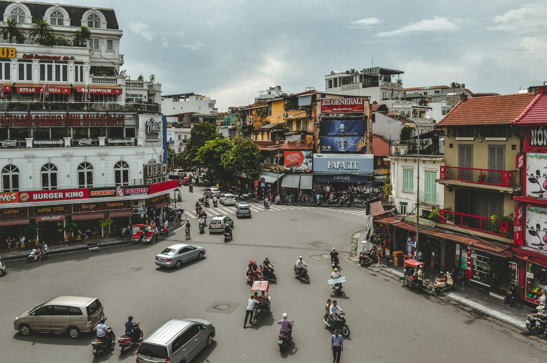
One of Asia’s most popular destinations and with good reason! Especially the last decade travellers have appreciated the vibrant Northern part of Vietnam , the great vibe and energy it represents along the cuisine and available activities in the region. The country is changing rapidly, it’s become a real manufacturing powerhouse. However many countryside destinations still offer a relaxed and authentic touch.
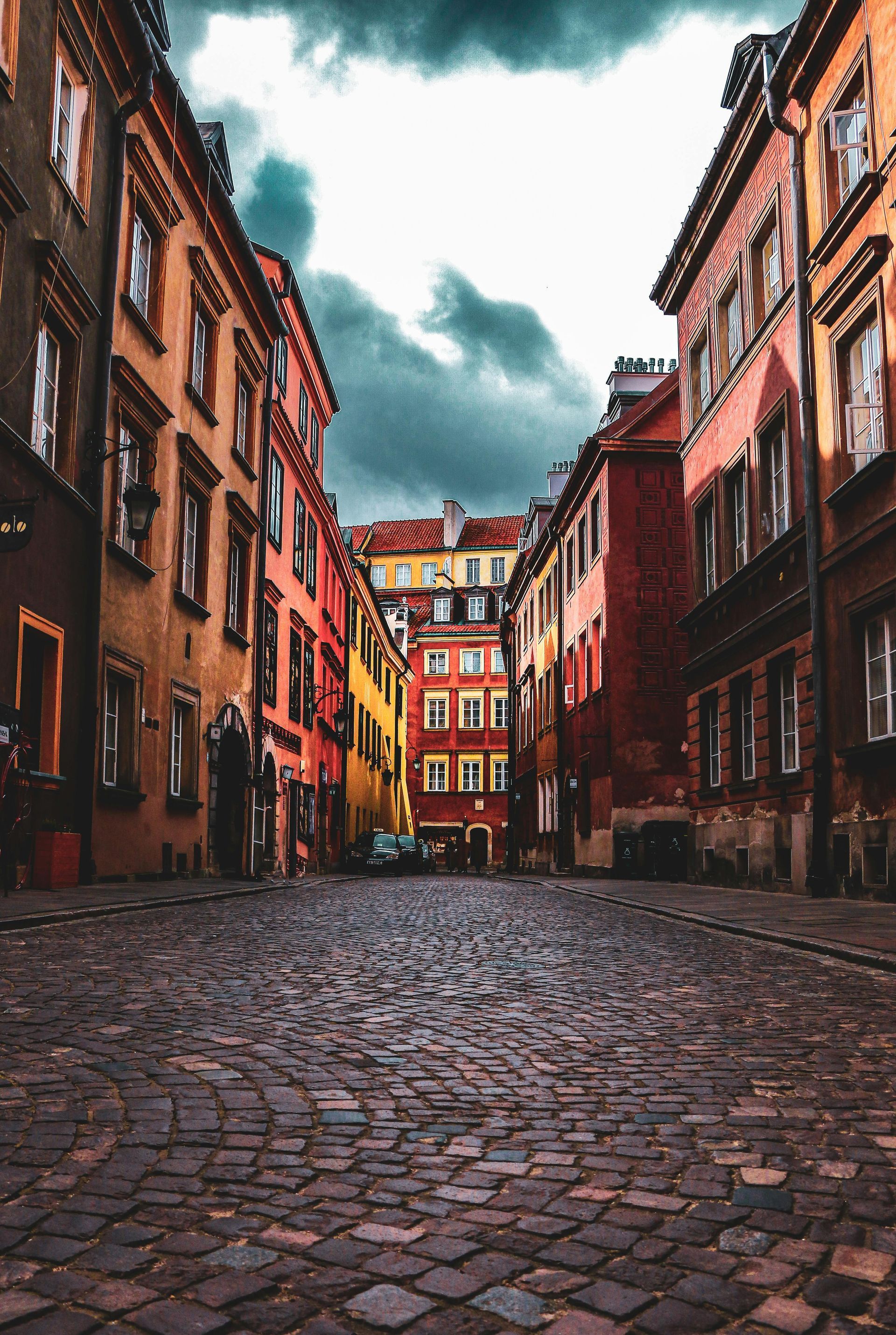
Poland is a country where medieval cities, dramatic history, natural beauty, and modern culture come together. Located in Central Europe, Poland offers travelers an affordable, safe, and richly rewarding experience—from fairy-tale old towns and UNESCO World Heritage sites to mountain trails, Baltic beaches, and vibrant nightlife. Poland has developed strongly economically in the last decade. It’s Europe’s fifth largest populated country and has a very solid manufacturing industry. Particularly food processing as well as packaging and there are many small & midsized logistical companies. Tourism is on the rise but still lagging behind the Czech republic or Austria. Poland is part of the European Union and the Schengen Area , making it easy to combine with trips to neighboring countries like Germany, Czechia, Slovakia, and Lithuania. Summer tends to be the favorite time to visit the country. Best Time to Visit Spring (April–June): Mild weather, blooming parks, fewer crowds Summer (July–August): Warmest season, festivals, outdoor cafés (busiest time) Autumn (September–October): Beautiful fall colors, cooler temperatures Winter (December–February): Snowy landscapes, Christmas markets, ski season in the south Ideal for most travelers: May–June or September Top Destinations Kraków – Cultural Capital One of Europe’s most beautiful historic cities. Especially in summer it’s very welcoming and pleasant although it can be hot. It tends to be very touristy as well. Use Guruwalk or Getyourguide to book walking tours and learn more about the city. Highlights: Rynek Główny (Europe’s largest medieval square) Wawel Castle and Cathedral Kazimierz (historic Jewish Quarter) Nearby Auschwitz-Birkenau Memorial Wieliczka Salt Mine (UNESCO site) Best for: History lovers, culture, architecture Warsaw – Modern & Historic Poland’s capital blends resilience and reinvention. The city has developed a lot in the past decade and is no longer very affordable - but there’s a rich, diverse restaurant offering. Highlights: Old Town (meticulously reconstructed after WWII) Royal Castle Łazienki Park & Palace on the Water POLIN Museum of the History of Polish Jews Thriving food, bar, and music scenes Best for: Museums, modern culture, city life Gdańsk – Baltic Beauty A colorful port city with maritime heritage. Highlights: Long Market (Długi Targ) Neptune’s Fountain Amber Museum WWII Museum Nearby beaches in Sopot and Gdynia (Tri-City area) Best for: Coastal charm, history, relaxed pace Zakopane & Tatra Mountains Poland’s mountain escape near the Slovak border. Highlights: Hiking in Tatra National Park Morskie Oko alpine lake Traditional wooden architecture Skiing in winter Highland (Górale) culture and food Best for: Nature, hiking, skiing Wrocław – City of Bridges & Dwarfs A lively city with a whimsical side. It’s also a large student university city with a very low unemployment rate. This is also thanks to several multinational companies having set up activities near the city. It’s well connected to Berlin and Prague. Highlights: Market Square Ostrów Tumski (Cathedral Island) Over 100 small dwarf statues hidden around the city Vibrant student atmosphere Best for: Photography, nightlife, charm Poznań – Birthplace of Poland Historic and youthful. Highlights: Renaissance Old Town Town Hall goats show at noon Strong food scene Important early Polish history Natural Attractions Białowieża Forest: Europe’s last primeval forest, home to wild bison Masurian Lake District: Kayaking, sailing, peaceful countryside Baltic Sea Coast: Sandy beaches, dunes (Łeba, Świnoujście) Ojców National Park: Cliffs, caves, castles near Kraków Polish Cuisine: What to Eat Polish food is hearty, comforting, and flavorful. Must-try dishes: Pierogi (dumplings) Bigos (hunter’s stew) Żurek (sour rye soup) Kotlet schabowy (breaded pork cutlet) Gołąbki (stuffed cabbage rolls) Oscypek (smoked mountain cheese) Desserts: Pączki (Polish doughnuts) Sernik (cheesecake) Makowiec (poppy seed cake) Drinks: Polish vodka (Żubrówka, Chopin) Craft beer (rapidly growing scene) Getting Around Transportation Trains: Reliable, affordable, extensive network. The fast train between Krakow and Warsaw is a breeze and very convenient. Buses: Often cheaper, good for smaller towns. The connections with Flixbus between the major cities are excellent and affordable. Domestic Flights: Limited but useful for long distances Car Rental: Ideal for countryside exploration Cities Walkable city centers Excellent public transport (trams, buses, metro in Warsaw) Costs & Budget Poland is one of Europe’s best-value destinations . Approximate daily budget: Budget traveler: €40–60 Mid-range traveler: €70–120 Luxury traveler: €150+ Meals, accommodations, and attractions are generally cheaper than Western Europe. Language & Communication Language: Polish English widely spoken among younger people and in tourist areas Learning basic phrases is appreciated: Dzień dobry – Hello Dziękuję – Thank you Proszę – Please / You’re welcome Safety & Practical Tips Very safe for travelers Watch for pickpockets in crowded tourist areas Currency: Polish Złoty (PLN) (not Euro) Cards widely accepted Tipping: Optional but appreciated (5–10%) Cultural Etiquette Dress modestly in churches Remove hats indoors Poles may seem reserved initially but are warm and helpful Respect historical sites, especially WWII memorials In short, why Visit Poland? Poland offers: Deep and moving history Stunning architecture Diverse landscapes Authentic culture Excellent value for money
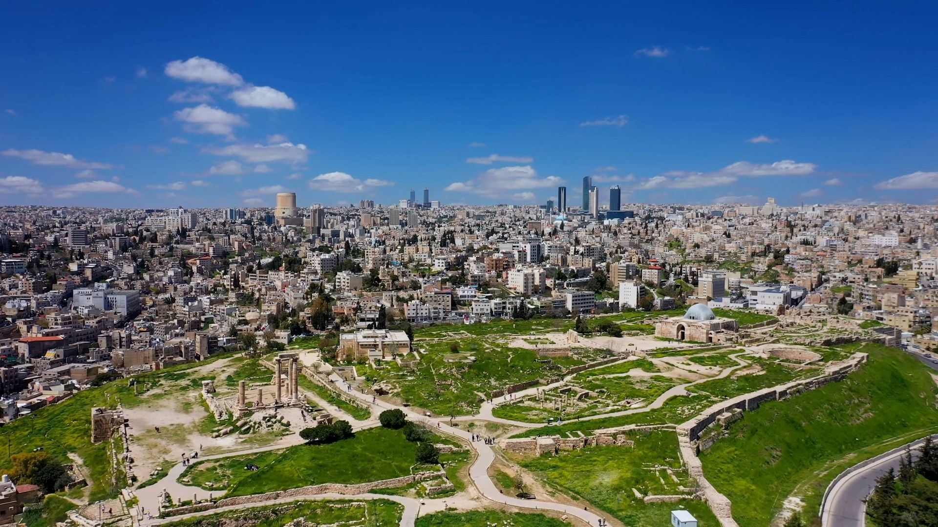
Jordan is a captivating Middle Eastern gem that blends ancient history, stunning natural landscapes, and warm hospitality. From the rose-red city of Petra to the otherworldly deserts of Wadi Rum and the buoyant waters of the Dead Sea, it's a destination that rewards adventurers, history buffs, and relaxation seekers alike. With a rich cultural tapestry influenced by Nabateans, Romans, and Bedouins, Jordan offers immersive experiences like hiking ancient trails, floating in mineral-rich seas, or savoring aromatic spices in bustling souks. As of late 2025, tourism is rebounding strongly, with improved infrastructure and eco-friendly initiatives in places like the Dana Biosphere Reserve. This guide covers everything you need for a memorable trip, including practical tips on arrival and navigation.
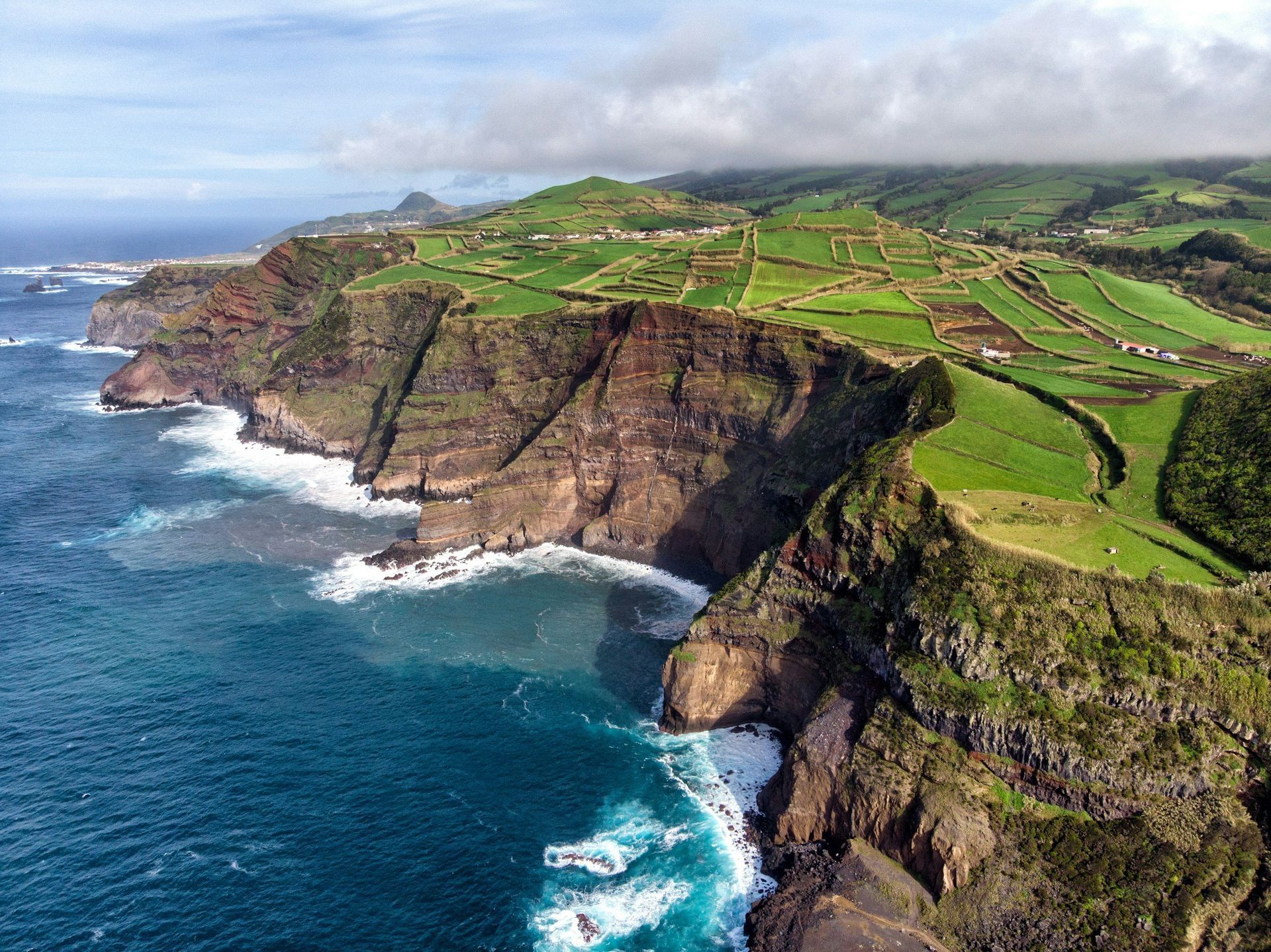
The Azores , an autonomous region of Portugal , is a stunning archipelago of nine volcanic islands scattered in the mid-Atlantic Ocean, about 1,500 km west of Lisbon and roughly 2,400 km from New York. Often called the "Hawaii of Europe" for its dramatic landscapes, lush greenery, crater lakes, hot springs, and volcanic peaks, the islands offer a mix of adventure, relaxation, and cultural immersion. Divided into three groups—Eastern (São Miguel, Santa Maria), Central (Terceira, Pico, Faial, São Jorge, Graciosa), and Western (Flores, Corvo)—each island has its own unique character, from São Miguel's verdant hills and tea plantations to Pico's towering volcano and UNESCO-listed vineyards. With a mild subtropical climate, biodiverse ecosystems (including 10% protected reserves), and activities like whale watching, hiking, and thermal bathing, the Azores appeal to nature lovers, hikers, and eco-tourists seeking an off-the-beaten-path European destination.
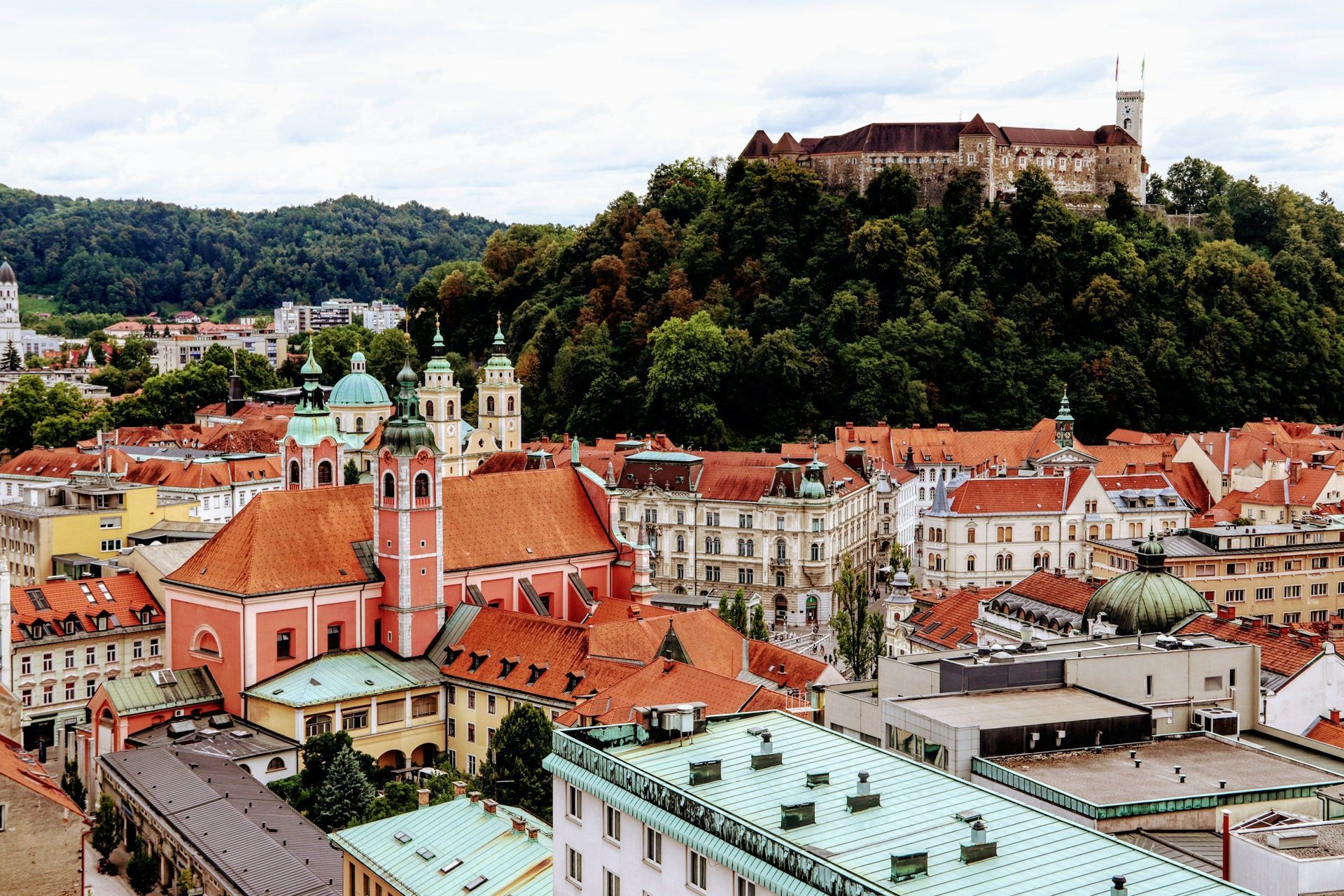
Slovenia , a compact European gem nestled between the Alps, the Adriatic Sea, and the Pannonian Plain, offers a diverse mix of stunning landscapes, vibrant cities, and rich cultural heritage. Bordering Italy, Austria, Hungary, and Croatia, it's known for its emerald rivers, alpine peaks, medieval towns, and UNESCO-listed sites. With a population of about 2 million, Slovenia is eco-friendly, safe, and affordable, making it ideal for nature lovers, adventure seekers, and cultural explorers. Its capital, Ljubljana, blends historic charm with modern vibrancy, while highlights like Lake Bled and the Soča Valley showcase its natural beauty. As of 2025, tourism continues to grow, emphasizing sustainable practices. The country is obsessed with sports, exercising in the great outdoors is very much a national hobby. And who doesn’t know world’s greatest cyclist Tadej Pogacar? He learned the ropes in his mountainous home country. Soccer and ski jumping are also popular. For visitors hiking is lovely and there’s so many trails in the forests or higher up in the Julian Alps.
